2017년 11월 15일 오후 2시 29분, 경북 포항에서 규모 5.4의 지진이 발생했다. 우리나라가 1978년 공식적으로 지진 관측을 시작한 이래 두 번째로 강력한 지진이었다. 규모 5.8로 역대 최고를 기록한 경주 지진이 발생한 지 불과 1년 만이었다.
그간 지진 발생이 잦지 않았던 국내에서는 사실상 지진 연구가 활발하지 않았다. 세계적으로 지진이 잦은 나라 중 하나로 꼽히는 이탈리아의 사례에서 지진 연구의 시사점을 찾아봤다.
인공위성으로 지표면 변화 모니터링
이탈리아는 아프리카와 유라시아 지각판의 경계에 자리 잡고 있다. 유라시아와 북아메리카, 필리핀판의 경계에서 조금 떨어져 있는 한국의 정반대편에 있는 셈이다. 한국보다는 판의 경계에 훨씬 가까워서 지진이 자주 일어나는 편이다. 2017년 한국에서는 규모 2 이상의 지진이 213회 발생한 반면, 이탈리아에서는 4500회 이상 발생했다.
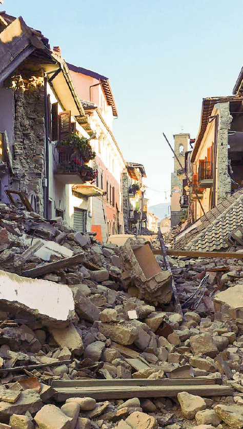
특히 2016년 8월 24일 이탈리아 중부 아마트리체 지역 인근에서 규모 6.2의 대형 지진이 발생해 299명이 사망했다. 이윤수 한국지질자원연구원 책임연구원은 “이탈리아는 히말라야 산맥처럼 두 개의 대륙지각이 만나는 조산대에 위치해 있다”며 “지각이 두껍고 일년 내내 눈에 덮여 있는 히말라야와는 달리 접근이 쉽고 거주 인구가 많아서 전 세계 지진학자들이 관심을 갖는 지역”이라고 말했다.
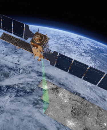
지진이 자주 발생하는 만큼 이탈리아 전역 약 350곳에는 지진 관측소가 설치돼 있고, 24시간 지진을 모니터링하고 있다. 특히 인공위성으로 지진 발생 전후 땅의 움직임 변화도 모니터링 하고 있다. 유럽우주국(ESA)이 발사한 인공위성 ‘센티넬(Sentinel)-1’(아래 사진)과 이탈리아 인공위성 ‘코스모-스카이메드(COSMO-SkyMed)’ 등이 현재 이탈리아의 지표면 변화를 실시간으로 추적하고 있다.
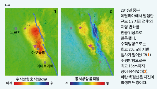
실제로 아마트리체 지진 발생 당시 긴급 구조 활동과 피해복구를 위해 피해 지역의 위성 이미지가 사용됐다. 영상에서 지표면 균열이 발생하지 않은 안전한 곳을 파악할 수 있기 때문이다. 지진이 일어난 단층을 빠르게 찾아내는 데도 인공위성 관측이 도움을 준다.
이 책임연구원은 “현재는 지진 발생으로 나타난 지표면 변화를 관측한 결과가 주를 이루지만, 지진 발생 전 발생하는 지표면의 융기나 침강 등의 변화를 관측하면 지진 연구에 더 큰 도움이 될 것”이라고 말했다.

지진 전조 현상 연구 활발
이탈리아에서는 전 세계 학자들이 함께 지진을 연구한다. 특히 지진 전조 현상 연구가 활발하다. 그간 지진으로 인한 인명 피해가 많았기 때문이다. 2016년 아마트리체 지진 피해 외에도 2009년 라퀼라 지역에서는 규모 6.3의 지진이 발생해 309명이 숨졌다(위 사진).
특히 라퀼라 지진은 작은 규모의 지진이 계속 발생하던 상황에서 지진 전문가와 시민 보호 담당 고위 공무원이 대중강연과 방송 인터뷰에 등장해 주민들을 안심시킨 상황에서 발생한 탓에 논란을 빚었다. 결국 잘못된 정보를 제공한 지진 전문가 6명과 시민 보호 담당 공무원 한 명이 과실치사 혐의로 재판에 넘겨진 초유의 사태가 벌어졌다.
이 일은 세계적으로 지진 예측의 한계와 과학자의 역할에 대해 많은 관심과 논의를 불러 일으켰다. 특히 지진 예측이 빗나갔다는 이유로 지진 연구자들을 처벌하는 건 불합리하다는 뜻에 동조한 전 세계 과학자 5200명 이상이 이탈리아 정부에 청원을 보냈다. 결국 2015년 11월 지진 전문가 6명은 과실치사에 대해 무혐의로 최종 판결났고, 시민 보호 담당자는 2년으로 감형됐다.
이탈리아 출신으로 영국 케임브리지대에서 생화학 박사를 받은 뒤 한국 기초과학연구원(IBS) 과학저술가(science writer)를 거쳐, 현재 유럽입자물리연구소(CERN) 홍보 담당으로 있는 레티치아 디아만테 박사가 이탈리아 지진 연구의 현주소를 짚었다.
○ Earthquakes: Under our feet _우리 발 밑에서 이탈리아 지진 연구 현장 이야기
- Written by Letizia Diamante | edited by Choi, Young Jun
In 2017, approximately 4500 earthquakes with a magnitude higher than 2, and 26 with a magnitude higher than 4 were recorded in Italy. It was a quiet year compared to 2016, when the National Institute of Geophysics and Volcanology (INGV) counted 10725 tremors, including those that destroyed Amatrice and other towns in central Italy. Although the risk of earthquakes in Korea is not as high as in Italy, recently earthquake threats have reemerged. Here it is an overview on earthquake-related studies, some “Made in Italy”, and the case of some Italian scientists who risked a jail sentence.
이탈리아에서는 2017년 한 해에만 규모 2 이상의 지진이 약 4500건이나 발생했다. 규모 4 이상의 지진도 4건이 발생했다. 2017년은 2016년에 비하면 조용한 해였다. 이탈리아 국립지구물리학및화산학연구소(INGV)의 발표에 따르면 중부 이탈리아에서 발생해 아마트리체 지역을 파괴시킨 지진을 포함해 2016년 한 해 동안 총 1만725건의 지진이 발생했다.
한국은 지진이 발생할 위험이 낮다고는 하지만 최근 포항 지진을 겪으면서 위기감이 고조됐다. 필자는 이탈리아에서 이뤄진 지진 관련 연구 결과와 잘못된 지진 예측 때문에 감옥에 갈 뻔한 이탈리아 과학자들의 이야기를 소개고자 한다.
Why are there so many earthquakes in Italy? 이탈리아에서는 왜 지진이 많이 발생할까?
Just some kilometers under our feet, a constant turbulent activity is taking place. Convection currents circulate, like a slow-motion conveyor belt, making the Earth’s most superficial layer slide. Oceans and continents are divided into huge “rafts”, technically known as tectonic plates. Italy lies on the boundary between the African and Eurasian plates. The two pull and push each other, making Italy very susceptible to earthquakes.
우리 발 아래 수 km 지점에서는 끊임없이 격동하는 움직임이 일어나고 있다. 맨틀 대류가 마치 느리게 움직이는 컨베이어벨트처럼 움직여서 지구의 최외각층을 이루는 지각을 미끄러지게 만든다. 해양과 대륙 지각은 마치 거대한 땟목처럼 나뉘어져서 판구조론에서 말하는 ‘판’을 형성한다.
The INGV monitors about 350 seismic stations across the country 24 hours a day, and publishes online an updated list of earthquakes, ranging from indiscernible tremors to violent shocks. Satellite images are also used to analyze ground movement before and after quakes. Looking at the earthquake map, it is clear that they tend to occur in areas that have been affected previously.
이탈리아는 아프리카와 유라시아판이 만나는 경계에 자리잡고 있다. 두 판이 서로 밀고 당기고 있기 때문에 이탈리아는 지진에 매우 취약한 지역이다. INGV는 이탈리아 전역에 약 350개의 지진관측소를 설치해 24시간 지진을 감시한다. 또 미소한 지진부터 큰 지진까지 발생한 지진을 모두 온라인에 업데이트한다. 여기에 지진 발생 전후 지각의 움직임을 분석하기 위해 위성 영상까지 활용한다. 지진 발생 기록을 보면, 전에 발생했던 지역에서 또 다시 지진이 발생한다는 걸 명확히 알 수 있다.
Earthquake forecasting 지진 예측
If an earthquake has struck a particular area before, chances are it will come back, but when? And how strong? These questions have challenged scientists for decades. Forecasting a majorquake within one week or month is beyond our abilities, it is only possible to measure a probability within a long window of time. For example, the United States Geological Survey (USGS) estimates that California will experience a very strong earthquake in the next 30 years with a probability of 76%.
만약 과거 특정 지역에서 지진이 발생했다면, 다시 발생할 가능성이 있다. 하지만 언제, 어느 정도의 규모로 지진이 발생할까. 이 문제는 수십 년 동안 과학자들을 괴롭힌 질문이다. 강한 지진을 발생하기 일주일 혹은 한 달 전에 예측하는 것은 우리의 능력 밖의 일이다. 오직 긴 시간 범위에서 가능성을 예측하는 것만 가능하다. 예컨대 미국 지질연구소(USGS)는 캘리포니아 지역에서 30년 내에 강력한 지진이 발생할 확률이 약 76%가 된다고 발표한 바 있다.
Nevertheless, people have been trying to find early warning signs. For example, a British scientist who was studying toads near L’Aquila (Italy) in 2009, reported that these animals altered their breeding behavior and fled their pond three days before the earthquake. Maybe the rocks have released some chemicals in the pond, but the exact explanation for this strange phenomenon is still elusive.
그럼에도 불구하고, 사람들은 연구자들은 초기 경고 신호를 찾아내고자 노력해 왔다. 가령 2009년 이탈리아 라퀼라 지역에서 두꺼비를 연구한 영국 과학자들은 두꺼비들이 번식 패턴을 바꾸고 지진이 발생하기 3일 전에 연못에서 달아났다는 관찰 결과를 보고했다. 연못에 있는 바위에서 화학물질이 배출됐기 때문일 수 있지만, 아직까지 이 기이한 현상을 정확히 설명하지 못하고 있다.
Another debatable indicator is the measurement of radon, a radioactive gas produced naturally by uranium decay. It can accumulate underground and leak out when rocks are fractured. This method was spotlighted in 2009, when a technician claimed to have predicted the earthquake in L’Aquila after measuring an increase of radon. However, since sometimes an increase of radon is not followed by a violent earthquake, the correlation is still unclear.
논란의 여지가 있는 또 다른 지표는 라돈이다. 방사성 가스인 라돈은 지각에 존재하는 우라늄이 붕괴하면서 자연스럽게 방출된다. 지하에 라돈이 축적될 수 있는데, 암석이 파열되면 새어나온다. 2009년 한 전문가가 이 방식으로 라돈의 변화를 측정해 라퀼라 지진을 예측하자 크게 주목받았다. 하지만 라돈의 증가가 지진으로 이어지지 않은 경우도 있어서 둘 사이의 상관관계가 불명확한 상황이다.
Another phenomenon that could help to predict imminent earthquakes is the sound emitted by the rocks when stressed and deformed. A team from the University of Cambridge (UK), Los Alamos National Laboratory and Boston University (USA) are training computers to predict tremors based on acoustic signals.
임박한 지진을 예측하는 데 도움이 되는 또 다른 현상은 암석이 스트레스를 받아 변형됐을 때 방출되는 소리다. 영국 케임브리지대와 미국 로스알라모스국립연구소, 보스톤대 연구팀은 음향 신호를 기반으로 지진을 예측할 수 있는 컴퓨터 프로그램을 개발 중이다.

Finally, more recently, geophysicists at the University of Colorado (USA) found that severe earthquakes appear five years after the slow-down of the rotation of our planet, which happens approximately every 30 years. As Earth’s rotation began one of these infinitesimally small periodic slow-downs around four years ago, we will soon know if these predictions are correct.
최근 미국 콜로라도대 지구물리학자들은 지구의 자전 속도가 느려지면 약 5년 정도 뒤에 강력한 지진이 발생한다는 경향성을 발견하기도 했다. 지구 자전이 느려지는 현상은 약 30년마다 주기적으로 발생한다. 지구의 자전 속도가 약 4년 전부터 느려졌기 때문에 이들의 분석이 맞아떨어질지에 대해서는 곧 알 수 있게 될 것이다.
Earthquake experts on trial 재판장에 선 지진 전문가들
There is currently no way to predict earthquakes, but scientists are often asked to deal with uncertainties when talking with laymen. In 2009, six of Italy’s most well-known earthquake experts and the deputy director of the Civil Protection Department were accused of giving “inexact, incomplete and contradictory information”. In a public talk, former INGV president was asked if a series of small tremors (foreshocks) felt by L’Aquila residents were precursors to a strong earthquake, and replied: “It is unlikely that an earthquake like the one in 1703 could occur in the short term, but the possibility cannot be totally excluded.”
현재 상황에서 지진을 예측할 수 있는 방법은 없다고 할 수 있다. 하지만 지진 전문가들은 전문적 지식이 없는 일반인들로부터 자주 지진을 예측할 수 있는지에 대한 질문을 받는다. 그런데 2009년 결국 문제가 발생했다. 이탈리아에서 가장 유명한 일곱 명의 지진 전문가들이 “부정확하고 불완전하며 모순되는 정보를 제공했다”는 이유로 구속됐다.
Separately, a reporter had an interview with the deputy director of the Civil Protection Department, who said: “The scientific community tells me there is no danger because there is an ongoing discharge of energy,” and when asked whether people should relax and enjoy a glass of wine, he cheerfully agreed.
INGV의 전임 소장은 대중강연에서 라퀼라 지역의 주민들이 느낀 미소지진이 강한 지진의 전조현상이 아니냐는 질문에 “1703년에 발생한 것 같은 지진이 근시일 내에 발생할 것 같지는 않다”면서도 “가능성을 완전히 배제할 수는 없다”고 말했다.
Some days later a magnitude 6.3 earthquake struck the city. L’Aquila’s medieval architecture, not equipped with earthquake-resistant structures, did not withstand.
이와는 별개로 시민보호국의 전임 부국장은 TV 인터뷰에서 “과학위원회에 따르면 현재 에너지가 계속 방출되고 있기 때문에 전혀 위험하지 않다”고 말했다. 이에 더해 주민들은 안심하고 와인을 즐겨도 좋다고 답했다.
Numerous buildings collapsed causing the death of 309 people. The experts and the deputy director were sued for the death of 29 victims, who reassured by the experts’ message, decided to stay indoors, instead of camping outside or sleeping in their cars.
하지만 불과 며칠 뒤 규모 6.3의 지진이 도시를 강타했다. 내진설계가 되지 않은 라퀼라 지역의 중세 건축물들은 지진에 무너져내렸고, 309명의 주민이 사망했다. 큰 인명피해가 발생하자 이탈리아 당국은 지진 전문가들을 29명의 희생자를 발생시킨 죄목으로 구속했다. 이들은 전문가들의 말을 듣고 지진을 대비하지 않고 집 안에 머물렀던 사람들이다.
As the experts were sentenced to six years in prison, more than 5200 international researchers signed a petition in support to their Italian colleagues. Later, six scientists were cleared of the manslaughter charges, and the punishment for the deputy director of the Civil Protection Department was reduced to two years.
지진 전문가들에게 6년형이 구형되자, 전세계 5200명 이상의 과학자들이 위기에 처한 동료들을 돕기 위해 탄원서에 서명했다. 결국 재판 과정에서 여섯 명의 과학자들은 과실치사 혐의를 벗었고, 시민보호국 전임 부국장은 2년 형으로 감형됐다.
The problem is that foreshocks do not necessarily lead to catastrophic earthquakes. If there was a warning for every foreshock, there would be too many false alarms and panic. Vice versa, the strong earthquake in Amatrice in August 2016 was not preceded by any foreshocks. Nevertheless, some people still think that the scientists’ message at the conference was misleading, and that they did not explain the uncertainties well enough.
이 사건에서 문제는 전진(前震)이 필연적으로 파괴적인 지진으로 이어지지는 않는다는 것이었다. 만약 전진이 발생할 때마다 경보를 울린다면 잘못된 경보가 너무 많아져서 혼란에 빠질 수 있다. 2016년 8월에 발생한 아마트리체 지진에서는 아무런 전진 없이 바로 강력한 지진이 발생했다. 그럼에도 불구하고 일부 사람들은 여전히 당시 과학자들의 메시지는 잘못됐으며, 지진 예측의 불확실성을 제대로 설명하지 않았다고 생각한다.
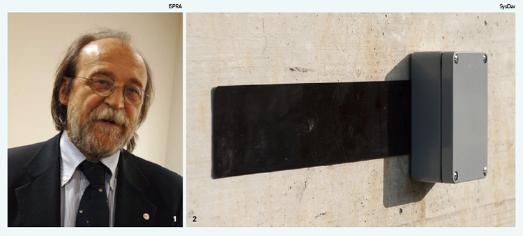
1. The former deputy head of Italy’s Civil Protection Department(person in the picture) and six scientists were sentenced to six years in prison for manslaughter charges following L’Aquila earthquake in 2009. Later in 2015, the scientists were acquitted by Italy’s Supreme Court of Cassation in Rome and the deputy head remained convicted but with a reduced jail term of 2 years. (시민보호국의 전임 부국장과 여섯 명의 과학자들은 라퀼라 지진 이후 과실치사 혐의로 6년을 구형받았지만 과학자들은 로마 대법원에서 무죄가 선고됐다. 전임 시민보호국 부국장은 유죄로 결정됐고 2년형을 선고받았다.
2. The Black Box of Infrastructures. It equipped wireless sensors that detect structural vibrations in buildings and transmit signals to cloud platforms.(건축구조물의 블랙박스. 이 장치는 무선 센서로 건물의 구조적인 진단을 감지해 클라우드 플랫폼으로 신호를 전송하는 방식으로 작동한다.)
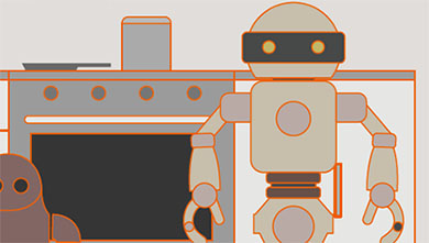
New disaster technologies using robots, IoT and smart doors 로봇과 IoT를 도입한 새로운 재난 기술
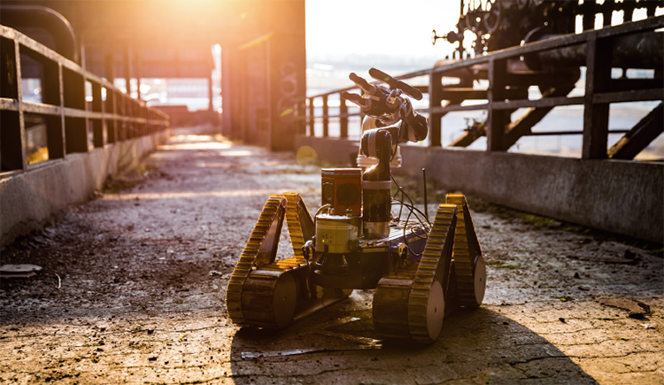
Since earthquakes are so unpredictable, scientists are trying to devise technologies to use in emergency situations. The Long-Term Human-Robot Teaming for Robot Assisted Disaster Response (TRADR) project uses robots and drones to enter damaged places. After the earthquake of August 2016, the team reached Amatrice within 48 hours to monitor the condition of two national heritage churches from the 14th century. Their data could help with the restoration.
이처럼 지진 예측이 어렵기 때문에, 과학자들은 비상 상황에 활용할 수 있는 기술을 개발하는 데 힘을 쏟고 있다. 유럽연합(EU)이 진행 중인 로봇지원재난대응팀(TRADR) 프로젝트에서는 로봇과 드론을 지해 지역 탐색에 활용하고 있다. 2016년 아마트리체 지진이 발생한 뒤에 이 팀이 48시간 이내에 아마트리체 지역에 파견돼 14세기에 지어진 문화재의 상태를 조사했다. 여기서 획득한 데이터는 복구에 활용할 수 있다.
Big data and Internet of Things(IoT) could also be helpful. The Italian company SysDev developed what they call “the black box of infrastructures”. These are wireless sensors that detect structural vibrations in buildings, and transmit signals to cloud platforms. Moreover, the Italian start-up LF System launched Quake Saver, a low-cost anti-locking system that prevents doors from blocking their opening during structural failures in earthquakes and other catastrophes.
빅데이터와 사물인터넷 기술도 유용하다. 시스데브(SysDev)라는 이탈리아 기업은 ‘건축구조물의 블랙박스’라고 부르는 무선 센서를 개발했다. 이 센서를 이용해 건물의 구조적인 진동을 측정해 클라우드 플랫폼에 전송하는 원리다. LF시스템이라는 벤처기업은 ‘퀘이크 세이버’라는 지진 등 재난이 발생했을 때 건물 내에서 문이 닫혀 탈출을 방해하지 못하도록 도와주는 시스템을 개발하기도 했다.
What are earthquakes good for? 지진이 주는 유익?
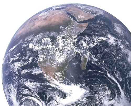
Although earthquakes can cause major disasters, they also represent the most useful opportunity to peer inside the Earth. Recently, a research team from Princeton University (USA) and the US Department of Energy’s Oak Ridge National Laboratory built a 3D map representing the Earth’s interior 2800 kilometers underground. As variations in the speed of the earthquakes’ elastic waves indicate differences in the composition, density, and temperature of the medium they travel through, scientists could outline several interesting phenomena hidden under our feet.
비록 지진은 큰 재난이지만, 지구 내부를 들여다 볼 수 있게 도와준다는 점에서는 유용하다. 최근 미국 프린스턴대와 오크리지국립연구소 연구팀은 2800km 깊이의 지구 내부를 형상화 한 3차원 지도를 구축했다. 지진에서 방출되는 탄성파의 속도가 매질의 조성과 밀도, 온도 등에 따라 변하기 때문에 이를 활용해 우리 발 밑에 감춰진 흥미로운 현상의 윤곽을 파악할 수 있다.